


Latest surveying technology to boost your productivity
Explore the latest technology that helps surveyors be faster and innovate workflows to meet client’s needs with fewer resources and outstanding quality.

Being at the forefront of innovation goes beyond introducing new technology. Our commitment to innovation ensures the latest technologies are easily deployed to ensure outstanding product performance and quality.

The world’s first tilt-compensated total station pole solution — Leica AP20 AutoPole
The AP20 AutoPole combines an intelligent sensor module with the new AP Reflector Pole and operates with Leica Geosystems’ existing automated total stations to create a unique solution for autonomous workflows.
The AP20 AutoPole opens up new possibilities and is the world’s first device on the market that solves three common workflow challenges. No longer need to hold the pole vertical and stable. See more aboutTilt Compensation.Entering the pole height manually into the field software.PoleHeight functionalitywill update the height for you as the pole height changes to ensure reliable and accurate measurements. Locking to a foreign target on a site with multiple reflectors.TargetIDenables the total station or MultiStation to identify your target on the fly during search. This prevents locking onto other targets, especially important when there are several surveyors working simultaneously at busy locations.

New Leica CS30 – An all-round surveying controller
Are you looking for an all-round field controller? Leica CS30 tablet is a versatile controller designed for durability. It is small enough to take along everywhere but has the power to perform a variety of survey jobs, use imaging sensors and work with drawings. With fast internet connectivity and a flexible and stable Windows operating system, the CS30 with Leica Captivate software links office, field and sensors. Visit our product page to discover why the CS30 is durable, carefree, designed for surveyors and fit for purpose.

One app for all terrestrial laser scanning portfolio
TheLeica Cyclone FIELD 360 mobile-device appis now extended to all Leica Geosystems 3D terrestrial laser scanners for in-field data acquisition and visualisation, enhancing the existing and well-established 3D reality capture workflow.
With the simple push of a button from the mobile-device app, all Leica Geosystems’ laser scanner users can capture high-quality data and verify registration directly in the field with a few simple clicks, saving valuable time in the office. The Leica ScanStation P-Series, the versatile, high-speed and survey-grade 3D laser scanners, now benefit from the existing workflow and proven productivity gains of the Cyclone FIELD 360 mobile-device app.

New reality capture management and collaboration for deliverable creation and rapid viewing
Our new, user-managed, enterprise-level reality capture collaboration and project management platform,Leica Cyclone ENTERPRISE, enables collaboration and deliverable creation across platforms. The new platform provides a central tool for managing, collaborating and accessing reality capture projects to view, share and analyse rich data via徕卡TruView生活- a new free web-browser based viewer.
气旋企业促进现实捕捉pro亚博ag真人规律ject management; provides access to rich, reality capture data though desktop programs and web browsers; and ensures secure, flexible, self-managed deployment.

Five automated total stations to increase productivity in any environment
We have enhanced our entire automated total stations portfolio in 2020. Starting with the new Leica Nova MS60 MultiStation and TS60 total station, now the newLeica TS16,TS13total stations and the newTM60 monitoring total stationare introduced. Our automated total stations range is designed to help surveyors achieve the highest measurement accuracy and reliability. Users of the automated total stations TS13, TS16, TS60 and the MS60 MultiStation can now measure the instrument’s height at a simple button press withAutoHeightand track them for theft deterrence and fleet management purposes withLOC8。TM60是我们监控全站仪,设计ed and manufactured for 24/7 monitoring. All automated total stations come with the easy-to-useLeica Captivate field software。Combined with a controller of choice, it enables surveyors to easily complete every field job with the broadest selection of onboard apps.
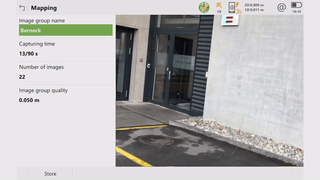
Measure What You See
The Leica GS18 I GNSS RTK rover with Visual Positioning, allows users to capture points of interest from a distance and measure points from the images in the field or the office. Visual Positioning technology (sensor fusion combining GNSS, IMU and a camera), allows users to reach previously inaccessible or obstructed points safely and efficiently. In addition to visual point positioning, the GS18 I inherits all the functionalities of a GS18 T, including the ability to map and stake out points with either tilted or levelled pole.
GS18 I users can use less time on site and continue measuring points with Leica Infinity software in the office. If new measurement needs arise, surveyors can measure additional points from the captured images. The GS18 I works with Leica Captivate field software for image capturing, on-site point measurement and quality assurance in the field. Discover how the GS18 I can make you more efficient.

Keep your competitive monitoring Edge
Surveyors are able to measure structural movements with millimetre-level accuracy, helping engineering companies and contractors face challenges by monitoring ever-changing structures and environments. Monitoring technology is constantly developing – it is becoming quicker and better. The new Leica GeoMoS Edge monitoring software component embedded in the communication device ensures 24/7 reliability with complete measurement data through autonomous sensor control in the field. Even in case of communication disruption, measurements are taken according to schedule and temporarily stored locally, thus preventing data gaps.

Your surveying partner
Only Leica Geosystems has 200 years of experience helping surveyors. Find out how we can support you with premium quality measuring and positioning solutions and services.
Only Leica Geosystems has 200 years of experience helping surveyors. Find out how we can support you with premium quality measuring and positioning solutions and services.

Grow your business
Discover how embracing digitalisation with technologies and processes can support your business to create new opportunities, stay competitive and improve productivity.
Discover how embracing digitalisation with technologies and processes can support your business to create new opportunities, stay competitive and improve productivity.

Engineering Surveying
Geared with the right equipment, software and services you can deliver construction and civil engineering projects on time and within budget while reducing waste and increasing safety.
Geared with the right equipment, software and services you can deliver construction and civil engineering projects on time and within budget while reducing waste and increasing safety.

Improve your skills
Learn the skills to be more efficient and react to business opportunities. Unlock your potential to offer better, faster and more specialised services to your clients.
Learn the skills to be more efficient and react to business opportunities. Unlock your potential to offer better, faster and more specialised services to your clients.